


rando michel

canal
User
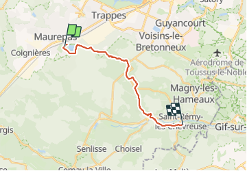

Length
16.8 km

Max alt
178 m

Uphill gradient
242 m
Km-Effort
20 km

Min alt
75 m

Downhill gradient
332 m
Boucle
No
Creation date :
2021-11-22 09:30:09.566
Updated on :
2021-11-22 15:08:50.379
5h37
Difficulty : Very difficult

FREE GPS app for hiking
 SityTrail
IGN / Geographical institutes
SityTrail Plus
The world is yours!
About
Trail Walking of 16.8 km to be discovered at Ile-de-France, Yvelines, La Verrière. This trail is proposed by canal.
Positioning
Country:
France
Region :
Ile-de-France
Department/Province :
Yvelines
Municipality :
La Verrière
Location:
Unknown
Start:(Dec)
Start:(UTM)
423194 ; 5400758 (31U) N.
Comments